I am reading about the
riverboat Arabia that sank on the Missouri River back in the 19th Century. The wreck was discovered about 30 years ago in a field. On
Google's satellite images you can see that there is some kind of industrial establishment near the site of the wreck, but
Google doesn't tell you what it is.
Maybe
Wikimapia can tell us. It might if we can get it to accept the coordinates. It doesn't like negative numbers, it wants direction letters (N, E, S, W) appended to the numbers, but even with those letters tacked on it wants to quibble. It seems like a fairly straight forward problem of interpretation.
Google has mastered it, why hasn't
Wikimapia? So I decide to file a complaint with the authorities.
The polite thing to do in these cases is to see if this is a known problem, so I go looking and I find
someone asking about UTM coordinates. What's UTM? More searching and I find the
Universal Transverse Mercator coordinate system. UTM was developed by the United States Army Corps of Engineers in the 1940s. Ah-ha! WW2 field artillery!
I love the smell of cordite in the morning.
Calculating the distance between two points on these maps could be performed more easily in the field (using the Pythagorean theorem) than was possible using the trigonometric formulas required [using] latitude and longitude. - Universal Transverse Mercator coordinate system
The
Wikipedia article about
UTM has a bunch of complicated math, but no real explanation of what's going on, so more searching. I turn up a
NOAA document that sounds promising. It doesn't really help, it's full of jargon, but it does contain this little bit:
Events occurring at Iowa State University, Ames, IA, in the late 1930's and the University of Pennsylvania in the early 1940s would effect nearly everyone in the world in the ensuing decades. These events led to the construction of the first automatic electronic digital computer (EDC), the Atanasoff-Berry Computer (ABC) by John V. Atanasoff and Clifford Berry in 1942. - Geodetic Surveying 1940-1990
While it might have been the first electronic digital computer, but it wasn't programmable, i.e. it was built for one purpose, to do map calculations. Getting it do anything else would have meant reconstructing it, kind of like trying to turn a forklift into school bus. The computers that showed up later, like ENIAC were reprogrammable. That way everybody gets to claim some kind of 'first'. And then I find this:
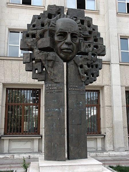 |
| Monument to John Atanasoff in Sofia, Bulgaria |
I can understand someone putting up this monument, people do that all the time. But why is it in Bulgaria?
John Vincent Atanasoff (October 4, 1903 – June 15, 1995) was a Bulgarian-American physicist and inventor. John's paternal grandfather was killed by Ottoman soldiers after the Bulgarian April Uprising.
The Order of Saints Cyril and Methodius, First Class, Bulgaria's highest scientific honor, was bestowed to him in 1970.
In 1990, President George H. W. Bush awarded Atanasoff the United States National Medal of Technology, the highest U.S. honor conferred for achievements related to technological progress. - paraphrased from Wikipedia
Those Turks always seem to be making trouble.


No comments:
Post a Comment