Sawing a Dam in Half (on Purpose)
Practical Engineering
Silicon Forest
If the type is too small, Ctrl+ is your friend
![]() |
| Map of western portion of Nord Stream Pipeline |
A week or so ago, somebody blew up the undersea pipeline that used to supply Germany with natural gas from Russia until Russia turned off the taps. So the pipeline wasn't actually piping anything at the time. Germany apparently thinks thinking positive thoughts are going to keep them warm this winter. Meanwhile, Germans are busy cutting down all the trees, digging up all the coal and burning all their trash to keep warm. And it's only October.
![]() |
| Satellite Image of Crimea Bridge |
A couple of days some troglodyte set off a bomb on the Crimea Bridge causing some damage and some disruption to traffic. Also killed three people who were unlucky enough to be passing the truck when it blew up. No mention of the truck driver.
![]() |
| Ukraine War Hot Spots Top to bottom: Dnipro Hydroelectric Power Plant, Zaporizhzhya Nuclear Power Plant, Mariupol, Crimea Bridge, Sevastopol Naval Base |
![]() |
| Dnipro Hydroelectric Station |
A giant freaking dam and power plant. The dam was built in the 1920's. Look what happened to it when the Nazi's tried to cross the Dniper river in 1942.
![]() |
| The dam at Zaporizhzhya after being blown up by Stalin's secret police in 1941. |
The Russian's blew it up. I suspect the Russian's were trying to repeat this event with their missiles. It might impact the water supply to Crimea which would be bad for Russia. Or maybe they were really trying to blow up apartment buildings and weren't trying to hit the dam.
![]() |
| Grand Ethiopian Renaissance Dam |
With a planned installed capacity of 5.15 gigawatts, the dam will be the largest hydroelectric power plant in Africa when completed, as well as among the 20 largest in the world. - Wikipedia
They started building it in 2011 and it started generating electricity this year.
I was thinking about putting up a post about this, just because I had never heard of this project before. Seems like I should have heard something about a big deal like this, but no. A couple of days ago I started reading Maelstrom by Peter Watts and somewhere in the first few dozen pages he mentions this dam. Well, I can't ignore a coincidence like this, so this post. I've read a couple other books by Peter Watts and he's pretty great.
Looking for information, I dug up some maps.
![]() |
| River Nile Map |
Google Maps doesn't do a good job of portraying waterways. Can't say as I blame them, only a small fraction of the population gets out on the water, and the government has a whole army of people devoted to mapping water. So if you want to look at maps of rivers, search for images of maps using your regular browser.
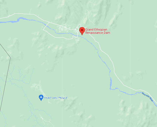
Still, Google Maps is terrific. Here we have two views of the area being inundated by the water being held back by the dam. Both maps are about 14 miles across. First is the map view:
![]() |
| Map View of Blue Nile Dam area |
No sign of any lake. The black line along the left hand side is the border with Sudan. Now look at the satellite view:
![]() |
| Satellite View of Blue Nile Dam area |
Update two days later.
![]() |
| Main Dam and Saddle Dam of GERD (Source: Hydro World, 2016) |
Looking at the satellite view of the lake I noticed a large, curved line in the lower left quadrant. A little digging reveals this is a three mile long saddle dam. The water hasn't reached it yet, but it means the lake is going to get a whole lot bigger in the coming years. The saddle dam is 160 feet tall. Not giant, but still substantial.
|
|
Lake Oroville Drought 1st photo - 2018 2nd - april 27, 2021 3rd -last week |
![]() |
| Spillway gates for the Akkat power station dam in Sweden |
![]() |
| California Pumped Power and Harvey's Bomb Oroville Dam is at the upper left, Helm's Creek Pumped Power Plant is at the lower right. |