Intel's Ronler Acres Plant

Silicon Forest
If the type is too small, Ctrl+ is your friend

Showing posts sorted by relevance for query Nile River. Sort by date Show all posts

Saturday, August 13, 2022

Grand Ethiopian Renaissance Dam

Grand Ethiopian Renaissance Dam

Ethiopia has built a giant freaking dam on the Blue Nile River just a few miles from their northern border where the Blue Nile River crosses into Sudan. Al Jazeera has a story.

With a planned installed capacity of 5.15 gigawatts, the dam will be the largest hydroelectric power plant in Africa when completed, as well as among the 20 largest in the world. - Wikipedia

They started building it in 2011 and it started generating electricity this year.

I was thinking about putting up a post about this, just because I had never heard of this project before. Seems like I should have heard something about a big deal like this, but no. A couple of days ago I started reading Maelstrom by Peter Watts and somewhere in the first few dozen pages he mentions this dam. Well, I can't ignore a coincidence like this, so this post. I've read a couple other books by Peter Watts and he's pretty great.

Looking for information, I dug up some maps.

River Nile Map

Note that the Blue Nile branches off of the main river at Khartoum. It heads southeast toward Ethiopia and just after it crosses the border is where the dam is.

Google Maps doesn't do a good job of portraying waterways. Can't say as I blame them, only a small fraction of the population gets out on the water, and the government has a whole army of people devoted to mapping water. So if you want to look at maps of rivers, search for images of maps using your regular browser.

Still, Google Maps is terrific. Here we have two views of the area being inundated by the water being held back by the dam. Both maps are about 14 miles across. First is the map view:
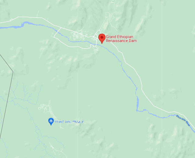
Map View of Blue Nile Dam area

No sign of any lake. The black line along the left hand side is the border with Sudan. Now look at the satellite view:

Satellite View of Blue Nile Dam area

Not a lot of contrast between the land and the water, but if you look carefully you might be able to pick out the shore line and see that the lake is extensive.

Update two days later.

Main Dam and Saddle Dam of GERD (Source: Hydro World, 2016)

Looking at the satellite view of the lake I noticed a large, curved line in the lower left quadrant. A little digging reveals this is a three mile long saddle dam. The water hasn't reached it yet, but it means the lake is going to get a whole lot bigger in the coming years. The saddle dam is 160 feet tall. Not giant, but still substantial.


Thursday, April 10, 2025

Ten Big Rivers

10 Big Rivers

I don't know about the plastic, this poster might be true, but I thought the way it showed these ten rivers is pretty cool, especially the Niger. I had no idea it curved around until it almost touches the coast. Must be some mountains there.

The sources of the Niger River, the Gambia River, and the Senegal River are all found in the Guinea Highlands. - Wikipedia

Thursday, August 3, 2023

The Monks of the Thebaid

A Thebaid: Monks and Hermits in a Landscapeabout 1505
Lorenzo Costa (Italian, about 1460 - 1535)

The Commondore by Patrick O'Brian. On page 266 we find the doctor sitting down to breakfast:
". . . being no more particular about washing, shaving and brushing than the monks of the Thebaid."

Thebaid? Getty Museum gives us this explanation of the above image, though it doesn't say anything about their personal grooming habits:

Using only pen and ink, Lorenzo Costa portrayed the cradle of Christian monasticism, the Thebaid, a Roman division of the upper Nile River valley. Beginning with Saint Paul of Thebes and Saint Anthony of Egypt in the 200s, Christian monks retreated to this region, to live a solitary life of ascetism and prayer. Over time, these monks, also known as "desert fathers," organized into communities.

Costa's scratchy, energetic draftmanship created a bustling composition filled with monks and a landscape riddled with the grottoes, huts, and caves they used for prayer and shelter. He portrayed an imaginary scene, incorporating a variety of monastic saints and spanning different periods. In the upper left background, Saints Paul and Anthony are shown seated, receiving bread from a raven through which God provided nourishment. Mary Magdalene, who supposedly lived her later years alone in the desert, stands near the river to the right. The landscape itself appears more European than Egyptian, perhaps reflecting Costa's native countryside around Bologna, Italy, rather than the real Thebaid.

A thousand years later there was also a Northern Thebaid in Russia. Now I wonder which one Stephen was referring to. Personal preference says the Egyptian ones as they were in the domain of the known world. Russia was like beyond the pale.

P. S. In the book, Thebaid has two dots over the i, not one, but every reference I saw on the net has just one.

Thursday, September 5, 2024

Djibouti Notes

Djibouti

I finally finished reading Djibouti by Elmore Leonard and now I'm finishing up my notes. 

The story is about Dara, a middle aged woman, who is in Djibouti with her assistant Xavier to film a documentary about the pirates operating out of Somalia. They meet Idris, a pirate leader, Billy, an American zillionaire, and his girlfriend Helen. Billy has a big sailboat that he sails himself. There is also Harry who is some kind of loose cannon with connections to the CIA or the military, it's never really clear. Jama is a full-blooded American terrorist. He got locked up in prison in the USA and converted to Islam and kept going.

The first 2/3 of the book are a bit of a slog. Eventually it occurred to me that Elmore may have been writing the way people talk which doesn't always translate into smooth reading. Also, in many of the scenes we have Xavier and Dara reviewing the films they have recorded that day and talking about whether what they have is good enough to be in their film.

Around about the 2/3's of the way though the book, things get lively, or rather deadly, with bodies falling left right and center. It's kind of a shock because up till then it's all cocktails, dancing and bravado.

Billy has 600 nitro express rifle. He loves to talk about it and mentions it every chance he gets. He also loves to show it off.


Cameron Mitchell shooting the .600 Nitro Express
Cam's Wild Life

LNG Tanker

While this story is meandering along, there is also a very ominous ship lurking in the background. It's a LNG (Liquified Natural Gas) tanker. Some Al-Qaeda thugs have managed to get on board and place some explosive charges that can be detonated with a call from a cell phone, all you need is the number. (And the ship has to be in range of a cell phone tower, along with a subscription that allows it to receive calls in that region of the world. Never mind this, the story never gets that far, I'm just picking nits.)

Jama has the number and is trying to decide on the best time to blow it up. His Al-Qaeda bosses have canceled this operation. This might have something to do with the gas coming from Qatar and the elite Qatarians support for terrorists. You know, if Al-Qaeda bites the hand that feeds them, they might not be getting any more doggy treats. None of that is in the story, it's just seems obvious to me. But Jama doesn't care. He likes being a terrorist and killing people.

The best place to blow up the tanker would be at an east coast port in the USA, if the gas gets delivered there. Everyone is aware of the situation, but the terrorists are no longer on the ship and no explosives have been found, so maybe there's nothing to worry about. But not finding any explosives does not mean there aren't any there, so maybe we should be worried. Billy's solution is to shoot it with his Nitro Express rifle and blow it up where it is, in the middle of the Red Sea. Multi-million dollar loss for the gas company, but not a disaster for people living around the delivery port.

While this topic is under discussion Xavier mentions the 1937 gas explosion disaster at the New London School in east Texas:


The New London School Explosion | A Short Documentary | Fascinating Horror
Fascinating Horror

While I was reading I took sporadic notes. Here are some things that get mentioned:

Page 45
USS Vella Gulf

Page 77

USS Bainbridge

Maersk Alabama Hijacking

Page 80 Aphrodite thousand foot long LNG tanker owned by bin Laden

Page 110 Remember we're talking about a federal system of people with semi-one track minds. You make a mistake you spend the rest of your career in a third world country so they sit on this till the twins go away.

Page 199 'the Song telling us "The sweet things in life to you were just loaned. So how can you lose what you never owned?"' - Rudy Vallee

Statue de Foch
Place du Trocadero, 75016 Paris France

Page 202 We have this passage:

Cars came around to take different streets off the Place Verdun, circling past the statue of Marshal Ferdinand Foch, 1851-1929, on a pedestal in the center of the plaza, the single word J'Attaque below his name.

Xavier said, "Ferdinand was asked what he'd do if surrounded by Germans and he said he'd attack. I believe it was at Verdun he lost somethin like eighty thousand men j'attackin." He said, "There's your man there."

So I go looking for Place Verdun and a statue of Marshal Foch in Djibouti but all I find it this poster:

Commandant Marchand - Across Africa Book Cover

"In 1896, Captain Marchand was appointed to lead the Congo-Nile mission to the White Nile River, with the aim of establishing a French protectorate in southern Egypt. Marchand led a team of eight French officers and 150 Senegalese skirmishers up the Congo, Ubangi and Bahr el-Ghazal rivers, arriving in Fashoda on 10 July 1898. They built a fort and raised the French tricolour flag. In September, the Anglo-Egyptian army under General Kitchener arrived at Fashoda. French and British colonialist ambitions came face to face at Fashoda, a standoff that ended in December 1898 when the French government ordered its troops to retreat to Djibouti."

Eventually I realized Xavier was just giving an example of a particularly bull-headed soldier to describe Buck, the soldier they were meeting. Although the French were in Africa, Marshal Foch was not.

Page 203 plant Epimedium otherwise known as horny goat weed

Page 215 Billy is talking about Medal-of-Honor winners:
  • Joe Foss shot down 26 Zeke's over the Solomons in his Grumman Wildcat and later became governor of South Dakota.
  • Major Bing Bang Bong flying a P-38 shot down 40 doing it during his tour and gave his life testing a jet. 
  • Another Ace, Pappy Boyington, a Sioux Indian, shot down his 26th over Rabul. Later that same day some nip sent Pappy down in flames. 
  • I forgot the name of the Navy pilot in a Dauntless crashing into a cruiser after he'd been hit. Another hero giving his life for his country, all Medal of Honor winners. He's probably referring to Colin Kelly who was flying a Vindicator, which is very similar to the Dauntless.

Page 217 1 cubic foot of liquefied natural gas will make 12,400 cubic feet of flammable gas air mix

Chapter 31 
Page 230 Golfo de Tadjoura
Page 243 Big Mucha Island

Previous posts: 

Thursday, July 4, 2019

Pyramids in the Sudan, Part 2

Pyramids of Meroë, Sudan
Archaeologists are exploring tombs underneath these pyramids. This project is complicated because these tombs have been flooded by the Nile River, just over a mile away. Hard to believe, but there are green fields just a quarter mile away from these pyramids.


I posted a map of some pyramids in Sudan once before. The new site is at the upper left in the above map, the old site is at the lower right. Both sites can be located using "Pyramids of Meroë", though you need to use Arabic to find the new one. To orient you in time and place, these pyramids date from 300 to 700 BC. Khartoum is 100 miles south, Cairo is almost a thousand miles to the north.

Via Roger Pearse

Sunday, June 14, 2015

The Cairo Affair by Olen Steinhauer

6th of October Bridge from the East bank of the Nile River to Gezira island in central Cairo, Egypt.
Modern day tale of espionage in North Africa. Good story, though the reason for someone turning traitor was a bit thin. To be fair, stealing secret documents was not presented as treason, it was implied that they were helping out some freedom fighters. Of course, it was all lies, but we get to the truth eventually.
    The story oscillates between the recent revolt in Libya that deposed Colonel Gaddafi and some events that happened to our heroes 25 years ago when the war in the Balkans was heating up. It gets a little confusing sometimes. You just have to keep the two time lines straight.
    Since we go to the Balkans, we get some history of the place and it's pretty grim. Nobody hates you like your neighbors hate you. It's got to be like a disease. I don't know what causes it, we don't seem to have the same trouble in the U.S. I suppose they learn it in kindergarten and polish it until they are big enough to make real trouble.
    As I was reading, I made some notes. When I was done I collated the information in a spreadsheet and plotted the places on a Google Map. Follow the links in the spreadsheet if you want to know more.

Note about the picture: I wanted a picture of the 15th of May Bridge as it gets mentioned a couple of times in the story, but I couldn't find one. Found several that purported to be the 15th of May Bridge, like this one, but were not. The 15th of May Bridge is downstream about a kilometer from this one. Good quality pictures were also a little difficult to find, that's why we have a skyscraper in the center of the picture.
    The 15th of May Bridge was named for the start of the 1948 Arab-Israeli war which is known in Arabic as the Catastrophe. The 6th of October Bridge was named for the start of the 1973 Yom Kipper War, which ended with a ceasefire. Egypt got their butt kicked, but like the Klingons, they declared victory and went home.

Tuesday, August 19, 2025

Why Africa is a Disaster

K T Cat has a post up:

His assertion, which he lays out thoroughly if you watch the whole video, which I recommend, is that the Africans had never seen a functioning country. Prior to colonial rule, they'd never experienced anything other than primitive, tribal society. Here's an excerpt. I have edited this transcript for clarity. Her dialog is in italics.

wherein he quotes from a Franck Zanu video:

We had tribal wars. And you must understand, even though the only thing African tribes have in common is skin color. Once we go to this tribe is a different language, different religion, different everything. Food, everything. It's like you've been to China, in France, except the way in the same region. Let people get this picture clear. It was a continent with only tribes.

(When the Europeans arrived in Africa) there was no republics. There were no countries. No modern day concept of what country means. There were no formal boundaries and borders. So let's talk about Benin itself. How many tribes were in Benin at that time? About 50. 50 different tribes or more... But you can't say Benin because there was no Benin. You can say the region. You see what I mean? It was a region that stretched all the way from the Nile River in Nigeria, all the way to Ghana, just a region. That's no name for anybody. There was nothing like Benin, Nigeria, Ghana. 

No. But there was a concept of Dahomey.

That's correct. That's a tribe ... That's one tribe of very brutal guys. Guys with potbelly married 200 wives, and they call them chiefs. And the foreigners named them kingdoms, because that is the only way they know from where they were coming from Europe. But there was no kingdom. We are not kingdoms.

It's any pot belly guy married to many women with his family making war on the other small tribes, and they were describing them based only on the word they know. The Europeans say, oh, this people's kingdom. It was only chiefs. We never had kings in Africa.

Explains a lot.


Monday, September 22, 2014

Googlicious

I'm checking out what I've said about pyramids and I get distracted looking at a satellite view of the Meroe Pyramids in Sudan. I zoom out and there isn't much to see except the Nile river and a couple of roads, or at least Google says there are a couple of roads there. Let's turn off the labels and see if what the place really looks like. Wait, what? No way to turn off the labels anymore?
    Google has had a new version of their map program floating around for a while and I just got a notice that all my maps had gotten moved to the new map ap. Well, that's the way of the world, change or die, and I suppose I can try to adapt. So how do you turn off the labels? Help takes me to some posts from numerous  people asking the same thing. No answer, but in reading along I turned up this little gem:

Sarah Sukhoi

Mar 10

There are two groups of people at google.

Engineers and Designers.

The Engineers used to run the company, smart people who made stuff that worked.

The designers are the ones who huff glue and then shout buzzwords like "WEB 2.0!" "MOBILE FUNCTIONALITY" "SOCIAL MEDIA ENABLED" like they are suffering from a nerdy form of tourettes.

Until about 3 years ago, google was run by the Engineers.  Somehow the Designers have made their way into the decision making positions and we get horrible products like Wave, Buzz, youtube comments tied to google, the new gmail, the new docs, and the new google maps.

Send feedback to google and tell them to put the engineers back in charge.  So we can get products that just work.
I couldn't fail to disagree less.

Update July 2019 replace pyramid link.


Saturday, August 15, 2020

Africa's Great Green Wall

Great Green Wall of Africa
Darker green areas need more work, light green areas need less work.
Click on map to embiggenate
It looks like some people have decided to tackle the growing desertification of Africa. I wish them luck. Most all of the information I found on this project is full of useless blather about climate change and social issues. I dunno, maybe that's what it takes to get a project like this moving. Lots of talk about how 'we're all going to work together' and maybe they will. Some places have made some progress.

The idea is to plant a wall of trees 10 miles wide clear across the continent of Africa along the southern border of the Sahara desert. The idea was originally proposed back in the 1950's.

Notice that there are a bunch of rivers below the line of demarcation, the only river above the line is the Nile.

Wikipedia has an article.

Via Reddit